Hiking the Old Fort Point Trail in Jasper National Park
This post may contain affiliate links. If you make a purchase through them, we may earn a small commission (at no cost to you).
One of the best things to do in Jasper National Park in summer is to hike the Old Fort Point loop trail.
Shaped by ancient glaciers, Old Fort Point is a giant craggy mound of bedrock looming 426 feet (130 meters) high above the surrounding valleys.
The views are truly epic!
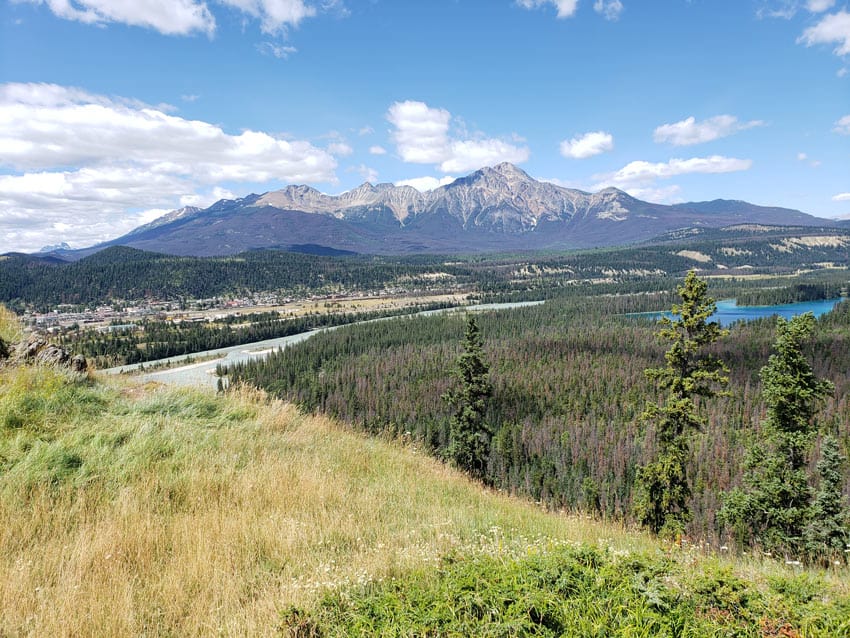
From the top of this mammoth limestone rock, you get 360-degree views of the Jasper Skytram terminal on top of Whistlers Mountain, the Jasper townsite across the wide rushing Athabasca River, and the iconic Fairmont Jasper Park Lodge snuggled up to the cobalt blue Lac Beauvert.
Now here’s the thing. We think the clockwise direction is the best way to do this popular trail.
So read on for everything you want to know about this great hiking trail in Jasper!
Jasper is open and welcomes visitors!
The Jasper community is rebuilding parts of the town and some surrounding park facilities after wildfire damage in July, 2024. Much of the park was untouched by the fire and many businesses are open. Some areas remain closed for safety, however.
For the latest updates on available services, trails and day use areas, Parks Canada’s page on what’s open.
Old Fort Point hike, Jasper

Thankfully, the Old Fort Point hike is an easy-to-moderate Jasper hike.
Compared to many all-day thigh-burners you find in Canada’s national parks, it’s also a reasonably short hike (short for Jasper, anyway).
If you’re looking for a half-day hike to super-charge your Jasper holiday, this loop trail packs a mega punch.
It’s one of the best hikes in Jasper National Park, thanks to its stunning mountain views and beautiful wildflowers adding pops of color along the way.
Old Fort Point hike stats
- Trail numbers: 1 and 1a
- Distance: 2.5 miles (4 km) for Trails 1 and 1a, or 2.3 miles (3.7 km) for Trail 1
- Elevation gain: 426 feet (130 meters)
- Hiking time: 1.5 hours (or 3 hours, if you dawdle like us and take lots of photos)
Old Fort Point trail map

Download a PDF of the above Jasper hiking map to enlarge the map of the Old Fort Point loop trail.
Getting to the start of the trail
The Old Fort Point trailhead is a mile (1.6 km) from the town of Jasper.
From town, make your way down Hazel Avenue across the railroad tracks, then across Yellowhead Highway 16.
Turn left on Old Fort Point Road.
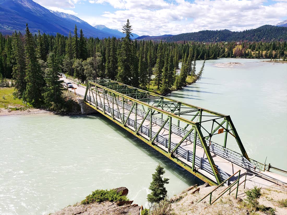
Drive across the Athabasca River on the Old Fort Point iron bridge.
You’ll see the parking lot on your right, just after the bridge.
Recommended route: Go clockwise
The fastest way to reach the top of Old Fort Point is via the steep wooden stairs leading up from the parking lot.
Many people go up this way. One couple we met on our way down told us they simply saw the stairs, wondered where they would lead and started climbing up.
We recommend what we think is a better alternative.
In our view, the best way to hike to Old Fort Point is to follow a clock-wise loop that takes you gently up a longer forested trail.
Then you take the stairs back down at the end.
The clockwise route is easier on your knees – and the panoramic views (like the climax in a blockbuster movie) make a bigger impact at the end.
Going up

Start at Trail #1 behind the signposted trail board at the edge of the parking lot.
The path is relatively flat and easy to begin with, through the trees.
Fireweed, Indian paintbrushes and other pretty mountain wildflowers line the trail.

Bears have been spotted here, so keep an eye out for them and be bear-aware.
We saw a pile of fresh bear scat (mixed with red berries) on the trail, reminding us to talk a little louder and make noise.
The trail then curves to the right and comes to a fork.
Trail #1a is a slightly longer .1 mile (.3 km) extension. Trail #1 rises at a shorter, steeper incline.
But both trails join up at the same place, leveling out at a viewpoint with two red Parks Canada chairs.

You get some great views here of the surrounding mountains and valleys below.
Sit for a while and soak up the scenery – Signal Mountain can be seen as you look east. And snap your Insta shots.

Then continue further a little way until you come to Old Fort Point, which looks like a large jagged ridge.
If you’re wondering about the Old Fort Point moniker, it’s most likely a reference to Henry House, which was built nearby in 1811 by the North West Company.
The cabin is believed to have been the first fur trading post in the Canadian Rockies.
Okay, now climb up the final 20 feet (6 meters) or so to the top.
And drink in the even more astounding views of Jasper and its surroundings from this second viewpoint.

Coming down

Once you’ve soaked up all the natural beauty around you, it’s downhill from here.
Be careful not to slip on the loose gravel and rocks on the steep sections of the wide slope. Walking down in a zigzag pattern helps.
Soon you’ll come to the steep staircases we mentioned earlier. They take you back to the parking area.

As you descend, you get terrific close-up views of the Athabasca River and the Old Fort Point Bridge.
One of the best easy Jasper hikes
Perhaps it was the warm sunshine, the blue skies, the splendiferous views and the pleasant breeze. Or the good company of family on the trail. Or maybe both.
But Old Fort Point was one of those perfect hikes for us – one of the nicest short hikes in Jasper we did on our family holiday.
Tips for hiking the Old Fort Point Trail

Best time to do this hike
While the hike can be done year-round, though you’ll be tromping through snow in the winter months.
The best time is from spring to early autumn. To see all the wildflowers, go in late spring or early summer.
What to wear
Light hiking boots are great to have. But as this hike is fairly easy, you can do it in running shoes.
Bring water and wear a sunhat in summer.
And because the weather in the Rocky Mountains is always changeable, you should dress in layers.
Hiking etiquette
Stick to the main trail to avoid trampling wildflowers and other native vegetation.
Also pack out what you pack in. (Don’t leave any garbage, please.)
Bear safety
This hike is in bear country, so be bear-aware.
Make noise (for example, occasionally clapping your hands or whistling loudly) to signal your whereabouts to any bears that happen to be around. Bears will try and avoid you if they’re aware of you.
You shouldn’t need to bring bear spray if you’re hiking in the summer, as you’ll see quite a few other hikers on the trail (and bears usually don’t like to be near people).
More easy hikes in Jasper
We also enjoyed several other Jasper day hikes on our visit.
Edith Cavell Meadows
The hike to Edith Cavell Meadows was another of our favorite trails.
You can make it short. It’s a touch over 1 mile (1.6 km) round-trip to see the face of the two glaciers: Angel Glacier and Edith Cavell Glacier.
We did the longer route up – about 5 miles (8 km) round-trip – continuing past the glaciers on Mount Edith Cavell, up through the forest and to the alpine meadows at the top.
Maligne Canyon
Another fairly simple day hike is along Maligne Canyon. Viewing Maligne Canyon is a must-do if you’re visiting Jasper for the first time.
For a short easy walk, park at the Maligne Canyon parking lot and make your way from the First Bridge to the Second Bridge, the highest point of the canyon.
Whistlers Mountain

Next time, we’d like to get tickets to ride the Skytram up Whistlers Mountain.
It’s Canada’s longest and highest guided aerial tramway, taking you up to a boardwalk at an elevation of 7,400+ feet (2,263 meters).
You can then hike a short distance (a little under a mile or 200 meters) to the peak of the mountain.
The views from the top there look like they would be even better on a good day than the views we enjoyed on the Old Fort Point Hike!
Pin to Pinterest!


Our top travel tips and resources
→ General trip planning: TripAdvisor is a helpful starting point, with loads of user reviews on hotels, restaurants and things to do.
→ Hotels: Booking.com is our go-to for scoring a “wow” hotel – or at least a decent one – often at lower rates than the hotel’s own website. (We especially like Booking.com’s flexible cancellation policy!) You can also find excellent discounted rates on Expedia, especially for hotels in the U.S. and Mexico.
→ Vacation homes, condos and rentals: We prefer and use Vrbo (Vacation Rentals by Owner).
→ Flights: For the best flights, we search on Google Flights first. Expedia and Kayak are then perfect for snagging the cheapest tickets. (They’re often non-refundable, though, so for more flexibility, we book directly with the airline, even if it costs more.)
→ Airport lounge access: We love (and have) Priority Pass for comfy lounge seats, free snacks and drinks, complimentary WiFi and sometimes even showers and spa services!
→ Tours: For the best local food, walking and other guided tours, plus skip-the-line tickets to attractions, check out Viator (a TripAdvisor company) and GetYourGuide.
→ Car rental: Renting a car can be a great way to explore off the beaten path. Discover Cars searches car rental companies for the lowest rates.
→ Travel insurance: SafetyWing is designed for frequent travelers, long-term adventurers and digital nomads. It covers medical expenses, lost checked luggage, trip interruption and more. We also have and recommend Medjet for global air medical transportation.
→ Travel gear: See our travel shop to find the best luggage, accessories and other travel gear. (We suggest these comfy travel sandals for city walking, the beach and kicking about.)
→ Need more help planning your trip? Check out our travel tips and resources guide for airline booking tips, ways to save money, how to find cool hotels and other useful trip planning info.
If you make a booking or purchase through our site, we may earn a small commission (at no cost to you). Thanks!
Photo credits: 3, 5, 6, 8 to 12 © Janice and George Mucalov, SandInMySuitcase | Hiking map courtesy Parks Canada | 7 Andrea Norrie
About the authors
